| News Details |
For the first time ((monitoring and following the floods of the valleys of the western region through satellites))
2022-12-13
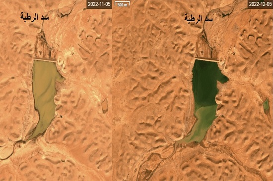
The Upper Euphrates Basin Developing Centre at the University of Anbar announced high-resolution satellite images of the floods that occurred in the western region at the end of November and the beginning of December 2022 through images taken by the European Space Authority's satellite.
The images showed the volume of the floods in the valleys of the western region, which resulted in an increase in the storage of dams on these valleys.
These images showed the increase in the water storage of the Rutba Dam, which is the largest dam in the region for the period from 5-11 to 5-12/2022, up to half of its storage capacity, which is almost equal to the calculations of the Planning Department. As for the Horan Dam/2, the images showed that the dam was empty on 20-11, while the storage reached good levels on 5-12, as the valley received good properties of runoff rains on 27/11/2022, which increased the storage by about one million cubic meters, according to the calculations of the Planning and Databases Department from the design storage of five million cubic meters.
As for the Horan Dam/3, the images showed that it was empty on 10/11/2022, while storage increased at good rates as a result of the floods on 27/11/2022, which was evident in the images taken on 5/12/2022.
This is the first time that floods and the resulting storage properties have been monitored using satellite images.
The Planning and Databases Department at the centre has high-resolution images of a large number of dams in the western region of Iraq for the valleys of Horan, Al-Agri, Al-Abyad and Al-Ga'ara area, which will be released in the statistics of the Planning and Databases Department in the coming days.
#university_of_anbar
#Upper_Euphrates_Basin_Developing_Center