
| News Details |
Challenges of Water Resources and the Geospatial Distribution of Lakes in Iraq
2026-04-23

Assistant Instructor Ala’a Yaseen Mohammed
Master's in Remote Sensing and Emissions – University of Baghdad
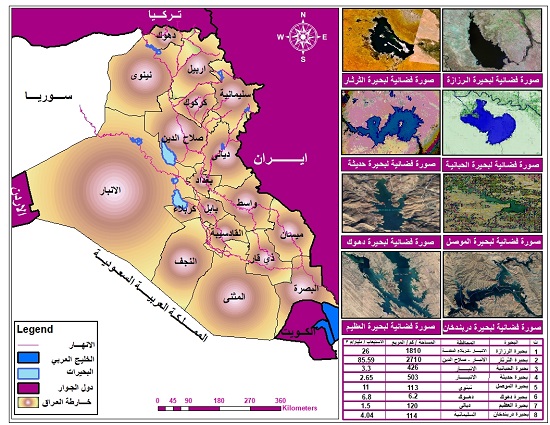
Lakes and water bodies in Iraq are distributed in an uneven geospatial manner, mainly concentrated in low-lying areas, along the course of the Tigris and Euphrates rivers, and in the western desert regions (natural lakes and depressions), while large artificial lakes are confined behind dams in the northern and central regions.
The geospatial distribution of lakes in Iraq can be divided into several main regions:
First: Dam and reservoir lakes (North and Central):
- Mosul Dam (Mosul Lake): Located in northern Iraq, it is the country's largest reservoir.
- Dukan and Darbandikhan Dams: Located in Sulaymaniyah Governorate (Kurdistan Region) on tributaries of the Tigris River (the Little Zab and Diyala rivers).
- Hamrin Lake: Located in Diyala Governorate, it was formed behind the Hamrin Dam for water storage and flood control.
- Haditha Dam: Located on the Euphrates River in Anbar Governorate.
Second: Lakes and Depressions of Central and Southern Iraq:
- Lake Tharthar: The largest natural depression used as a flood reservoir, located between the Tigris and Euphrates rivers north of Baghdad.
- Lake Habbaniyah and Lake Razzaza: Located in Anbar Governorate west of the Euphrates River, these are large natural depressions.
- Marshes: Concentrated in southern Iraq (such as the Hammar Marshes and the Hawizeh Marshes), these are natural water bodies that constitute a unique ecosystem.
Key Components and Challenges of Water Resources in Iraq:
Main Sources: Iraq relies 100% on surface water, primarily the Tigris and Euphrates rivers, in addition to the Tigris' tributaries (Greater Zab, Lesser Zab, and Diyala), most of which originate in Turkey and Iran.
Scarcity and Drought Crisis: Water levels have dropped to their lowest point in 80 years, leading to the drying up of vast areas of agricultural land and marshes.
External Impacts: The construction of dams and irrigation projects (such as dams on the Tigris tributaries) by neighboring countries (Turkey and Iran) has directly impacted water inflows.
Strategic Reserves: The storage capacity of dams is approximately 100 billion cubic meters, but the actual available reserves have decreased significantly.
Pollution Challenges: Water faces increasing pollution due to sewage and runoff from agriculture.
Proposed solutions to address the crisis:
-
- International negotiations: The necessity of reaching binding agreements with neighboring countries to establish equitable water quotas.
- Enactment of a federal water law: To regulate water management as a shared national resource among all regions.
- Adoption of a long-term strategy: This includes modernizing irrigation methods, reducing waste, and effectively managing dams.
- The distribution of lakes is uneven, concentrated mainly in low-lying areas and along the Tigris and Euphrates rivers in Iraq, as shown in the table below.
A table showing the distribution of lakes across governorates, their storage capacity in (billion m3), and their construction dates.
|
No. |
Lake |
Location |
Date of construction |
Storage capacity |
|
1 |
Razzazah |
It is located (70 km) south of Lake Habbaniyah and (15 km) west of the city of Karbala, |
1941 |
26 billion m3 |
|
2 |
Habbaniyah |
The Habbaniyah project is located on the right bank of the Euphrates River near the city of Ramadi. |
1943 |
3.3 billion m3 |
|
3 |
Therthar |
It is located 120 km northwest of Baghdad between the Tigris and Euphrates rivers. |
1976 |
85.59 billion m3 |
|
4 |
Duhok |
Duhok Dam Lake is located in Duhok Governorate in the Kurdistan Region of Iraq, only about 2 km north of Duhok city. |
1988 |
47.51 million m3 |
|
5 |
Mosul |
The Mosul Dam reservoir is located in northern Iraq, within the Nineveh Governorate, approximately 50 kilometers northwest of the city of Mosul. |
1986 |
8.16 billion m3 |
|
6 |
Adhaim |
It is located in Diyala Governorate, eastern Iraq, north of Baquba city, specifically on the Al-Adhaim River. |
1999 |
1.50 billion m3 |
|
7 |
Darbandikhan |
Located in Sulaymaniyah Governorate in the Kurdistan Region of Iraq, approximately 60 km southeast of the city of Sulaymaniyah |
1961 |
3 billion m3 |
|
8 |
Haditha |
It is located in Anbar Governorate in western Iraq. It has an artificial lake formed behind the Haditha Dam on the Euphrates River, extending north of the city of Haditha, and is about 260 km west of the capital, Baghdad. |
1978 |
10.0 billion m3 |
#Upper_Euphrates_Center_for_Sustainable_Development_Research




