| News Details |
Brief Report on the Current Cold Wave
2025-12-29
The Meteorology Department at the Upper Euphrates Center for Sustainable Development Research – University of Anbar announced the latest updates on the current cold wave affecting Iraq. Dr. Ahmed Jassam Mukhlif, Head of Meteorology at the Center, stated the following:
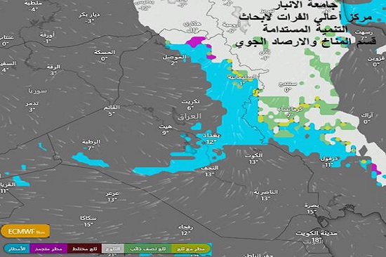
The European model currently shows an analysis of three types of precipitation over Iraq, based on the colors shown at the bottom of the map. Precipitation can be analyzed as follows:
Snow (white/light gray) is concentrated heavily over the mountainous regions of northern Iraq, eastern Turkey, and western Iran.
Frozen and mixed precipitation (purple and green) is observed in the transitional zones between the mountains and the northern plains. Rain (sky blue) covers a wide area, including parts of central Iraq (north of Baghdad, Tikrit, and Mosul) and extending laterally towards the western border. A special case is observed: an isolated rain/snow patch is present in the far west near Rutba, indicating sufficient moisture for condensation despite the extreme cold there.
Temperatures:
Western regions (desert plateau) are recording low temperatures (2°C at dawn), indicating a strong frost wave.
Northern and mountainous regions are experiencing low temperatures approaching or below zero (Sulaymaniyah -3°C).
Central and southern regions are experiencing relatively low temperatures, but higher than the north (Baghdad 4°C, Basra 8°C).
Wind movement:
The smooth white lines indicate a cold, dry northwesterly wind movement in the southern and western regions, while the winds appear more turbulent (rotating) in the northern and central regions, reinforcing the presence of the low-pressure center in those areas.
Conclusions and Recommendations
Frost Warning: In western and northern regions due to sub-zero temperatures.
Alert for mountain road users: Due to expected heavy snowfall in Sulaymaniyah and border areas, the map indicates the peak of the cold air mass's penetration into the heart of Iraq.
#Upper_Euphrates_Center_for_Sustainable_Development_Research