| News Details |
Weather Forecast for the Next Few Days
2026-01-09
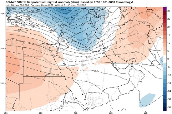
The Meteorology Department at the Upper Euphrates Center for Sustainable Development Research at University of Anbar announced satellite forecasts based on dynamic analysis of the upper atmosphere (500 mb). Assistant Professor Dr. Ahmed Jassam Mukhlif, Head of Satellite Meteorology, stated that, based on the attached map from the European Centre for Medium-Range Weather Forecasts (ECMWF), the geopotential height at the 500 mb level is showing an anomaly for Friday and Saturday, January 9-10, 2026.
Analysis of the Upper Atmosphere System (500 mb Level):
The atmospheric pressure in the upper layers is lower than its annual averages due to the influx of a cold air mass in the upper atmosphere (a trough). There is a direct correlation between temperature and geopotential height. Cold air is denser and has a smaller volume, causing the atmospheric layers to compress downwards. This leads to atmospheric instability, Insha’Allah. When pressure values ??drop (becoming negative), this acts like a "magnet," pulling air from the surface upwards (a dynamic lifting process). This results in precipitation depending on the interaction between surface moisture and upper-level cooling.
Surface Pressure and Precipitation Systems Analysis (MSLP & Precipitation):
The northern regions and Mosul are most affected by this low-pressure system. Rainfall, sometimes intermittent, is expected. As the cold air deepens in the upper atmosphere, the chances of snowfall increase over high and medium-altitude mountain peaks. The central regions (including Baghdad) are under the influence of the leading edge of the cold trough. God willing, they will experience cloud cover at varying altitudes, with a chance of scattered showers, especially in the western and northern parts of the central region – Anbar – becoming concentrated in Baghdad, Hilla, and Diyala later at night. The southern regions appear to be less affected, with the possibility of light and scattered rain. On Saturday, the rain will be concentrated in the eastern parts of Iraq.
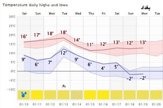
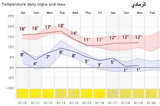
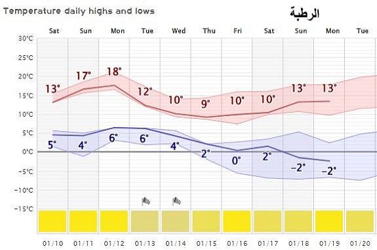
Temperatures
A significant drop in temperatures is expected, starting in the western and northern regions and gradually spreading to the rest of the country as the low-pressure system moves eastward. The mountainous region (Duhok, northern Sulaymaniyah, and Erbil) will experience a continuous and polar drop.
Maximum temperatures:
MAX.T. will fall from 11°C to stabilize at 0 to 4°C during the peak of the cold wave.
Minimum temperatures
MINI.T. will register sharply negative values ??ranging from -2 to -8°C, leading to widespread freezing and heavy snowfall.
The northern region
The governorates of (Mosul, Kirkuk, and northern city centers) will experience a significant drop in temperatures, from relatively cold to very cold.
Maximum temperatures will range between 12 and 14°C initially, then break to reach 7°C.
Minimum temperatures will drop sharply to approach zero degrees Celsius (0°C to -2°C) by the end of next week. The central region (Baghdad, Anbar, Salah al-Din, Diyala) will experience relatively stable temperatures until Tuesday, followed by a sudden drop on Wednesday night that will last for five days.
Maximum: After Tuesday, temperatures will drop rapidly to around 9°C.
Minimum: Temperatures will decrease to between 2°C and 3°C, increasing the chances of morning frost.
The southern region (Basra, Nasiriyah, Amarah) will experience warm weather during the day, ending with a noticeable but less severe drop in temperatures than in the central region.
Maximum: Temperatures will reach around 20°C mid-week, then drop to 16°C.
Minimum: Temperatures will decrease from 13°C to settle at 9°C, accompanied by active northwesterly winds.
Almighty Allah knows best.
#Upper_Euphrates_Center_for_Sustainable_Development_Research