| News Details |
Iraq Weather Forecast
2026-02-17

The Meteorology Department at the Upper Euphrates Center for Sustainable Development Research announced weather developments for Tuesday night (from 8 PM to 5 AM). Assistant Professor Dr. Ahmed Jassam Mukhlif, climate expert and head of satellite weather forecasting at the center, stated that in a rapid and significant change in weather conditions on Tuesday evening, February 17, 2026, the country will exposed to:
Dust storm before rain
Based on active wind patterns, a wide area of ??suspended dust and raised sand is currently extending from the Syrian Desert and Anbar to the central regions due to southwesterly downdrafts preceding the rain front. These winds will exceed 50 km/h in strong gusts, resulting in a dust storm and a significant decrease in horizontal visibility, especially in open areas and on roads.
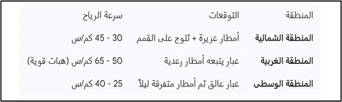
Rainfall Situation:
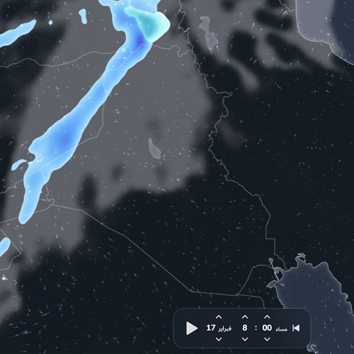
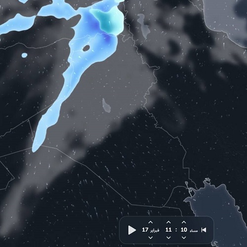
As the latest radar images and weather maps indicate, a frontal low-pressure system accompanied by a cold air mass is currently centered over the eastern Mediterranean basin and is gradually moving towards Iraq and the Levant.
Areas of Impact: Northern and western Iraq/eastern Syria are experiencing heavy thunderstorms. Snowfall is also expected over mountainous areas above 1200 meters due to temperatures dropping to near freezing.
As for the central regions (Baghdad and Anbar): Cumulonimbus clouds will begin to gradually move in over the next few hours, bringing varying intensities of rainfall starting from the west and spreading inland, where scattered showers are possible. See below for details.
#Upper_Euphrates_Center_for_Sustainable_Development_Research