| News Details |
Heavy Rain and Severe Storms: A Rare Deep Low-Pressure System Affects the Country
2026-03-23
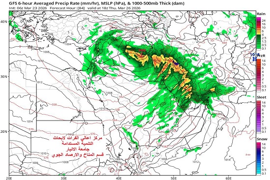
The Meteorology Department at the Upper Euphrates Center for Development Research announced stable weather conditions for the coming days. Assistant Professor Dr. Ahmed Jassam Mukhlif, Head of Satellite Meteorology, stated that the weather tomorrow, Tuesday, March 24, 2026, will be heavy with rain across most of the country, with scattered thunderstorms. The storm is expected to reach the Red Sea from the Mediterranean, bringing, Allah willing, a strong instability to heavy rain and strong thunderstorms, particularly in the southeastern regions of the country, with wind speeds potentially reaching 40 km/h. The distribution of rain and temperatures for Tuesday night is as follows:
North (Nineveh, Erbil, Sulaymaniyah, Dohuk): Moderate to heavy rain, with temperatures ranging between 13–17°C.
Western (Anbar): Moderate rain with wind activity, temperature around 21°C.
Central (Baghdad, Babylon, Karbala, and Najaf): Heavy rain with thunderstorms, temperature between 21–24°C.
Southern (Basra, Dhi Qar, Maysan): Intermittent rain that may be heavy, high temperature between 25–26°C.
However, the weather forecast until Wednesday, March 25, 2026, is partially consistent, with a continued chance of scattered rain, particularly in the northern and northeastern regions.
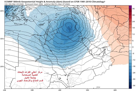
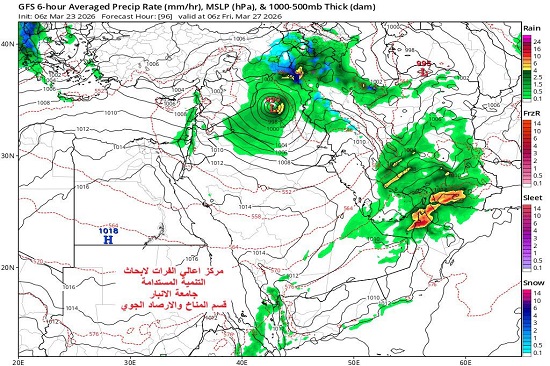
The weather forecast for Thursday and Friday, March 26-27, 2026, as indicated by the Arab Center (ECMWF) and the American (GFS), suggests that a polar air mass is expected to descend over the eastern Caribbean Sea, converging with another air mass over the Arabian Peninsula. This will create moist, tropical-origin southwesterly air currents, Allah willing, resulting in a low-pressure system. Its initial impact will be felt in western Iraq, with significant differences in temperature today. This system is exceptionally deep and rare, unlike anything seen in the past two decades. Geopotential pressure readings (500 millibars) at the Earth's surface indicate values ??of 988-992 hPa. This type of weather pattern is expected to be experienced globally, bringing heavy rainfall across a wide area and causing severe flooding, particularly in valleys and low-lying areas. Severe thunderstorms are also anticipated, potentially reaching storm force level (11) on the Beaufort scale, with potentially high speeds. Baghdad may be affected.
The risks:
Although the fact that rainfall is beneficial for water storage, the intensity of rain could lead to the spoilage of some crops. The damage of Land transportation routes may be possible due to the heavy rain and wind.
#Upper_Euphrates_Center_for_Sustainable_Development_Research