| News Details |
Upper Euphrates Center Releases Warning Maps of Areas Expected to Experience Rising Water Levels in the Tigris and Euphrates Basins
2026-04-12
The Upper Euphrates Center for Sustainable Development Research at University of Anbar announced the publication of a set of specialized maps showing areas expected to experience rising water levels within the Tigris and Euphrates river basins as a result of rainfall across various regions of Iraq. This initiative is part of the center's efforts to enhance monitoring and early warning systems.
The center explained that these maps accurately depict areas near riverbanks that are likely to be flooded due to increased water flow, thus serving as an important tool to support public safety measures.
The center also emphasized that this step aims to warn and alert citizens, especially those engaged in various activities near riverbanks, to the necessity of taking precautions and following preventative guidelines to avoid potential risks.
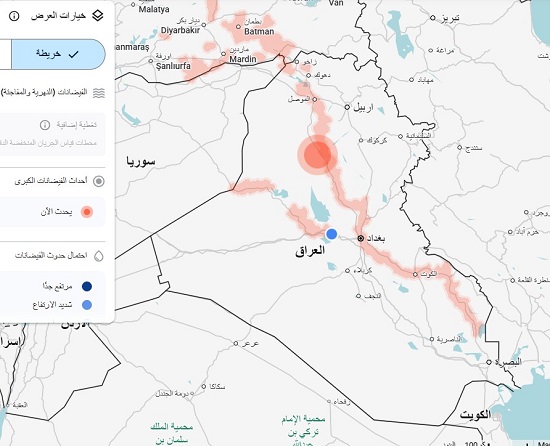
The attached map shows a live flood risk alert for Iraq, associated with the expected rainfall, as follows:
Analysis of colored points (risk hotspots):
- The analysis of colored points (danger focus):
The large red circle (north of Baghdad - Samarra/Tikrit area): This area is experiencing peak flood risk. This means there is a massive water flow exceeding the capacity of the Tigris River at this point.
- Areas shaded in light red: These represent the natural basin of the Tigris River and the marshlands or water-filled depressions. This shading extends from the north to Amarah, Nasiriyah, and Basra, indicating that the entire Tigris River is under water stress.
Assistant Professor Dr. Ahmed Jassam Mukhlif, a satellite meteorology expert, pointed out that providing this service is an important support for researchers and those interested in the field of water resources, as well as an effective tool for decision-makers. These maps contribute to the preparation of emergency plans and crisis management related to natural disasters, especially floods.
The Upper Euphrates Center continues its efforts in developing databases and predictive models that contribute to enhancing the ability to adapt to climate change and reducing its effects on local communities.
#Upper_Euphrates_Center_for_Sustainable_Development_Research