| News Details |
The Meteorology Department at the Upper Euphrates Center declares expected rainfall in the coming days
2026-04-15
The Meteorology Department at the Upper Euphrates Center for Sustainable Development Research declared expected rainfall in the coming days, ranging from moderate to heavy, affecting several regions of Iraq, particularly the northern and northeastern areas.
Assistant Professor Dr. Ahmed Jassam Mukhlif explained that these forecasts are based on meteorological data and satellite image analysis, which indicate the possibility of the Tigris and Euphrates river basins being affected by rainfall that could lead to rising water levels in some areas, especially those near rivers and natural depressions.
In this context, Dr. Mukhlif stated that satellites provide updated maps of expected floods within the Tigris and Euphrates basins, aiming to support early preparedness efforts, provide accurate information to relevant authorities and decision-makers, and warn citizens in at-risk areas.
The potential flood risk in the Tigris and Euphrates basins deserves attention to warn residents in danger zones.
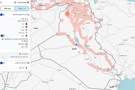
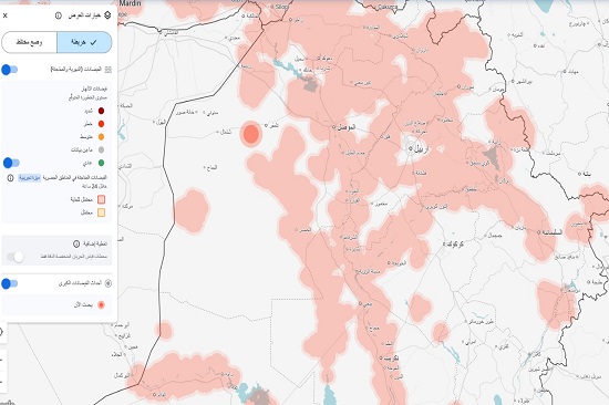
Based on the attached map dated April 15, 2026, the analysis of the flood situation in the Tigris and Euphrates basins shows the following:
- Identifying Danger Areas (Hotspots)
High risk (in dark red and wide circles) is concentrated in the following areas:
- Northern Iraq (Upper Tigris Basin): A very high risk hotspot (large red circle) is located north of Mosul and extends to areas in Duhok Governorate.
- Border Region (Iraq-Turkey): There is high flood activity at the headwaters of the Tigris and Upper Zab rivers.
- Central and Southern Iraq: River courses appear in light red, indicating rising water levels in the Tigris River as far south as Baghdad and the Nasiriyah and Amarah regions, though less pronounced than in the northern regions.
- Why these areas are considered dangerous? (Scientific reasons)
According to the data available on the map and the climatic conditions associated with this time of year:
- Snowmelt Season: April is the traditional peak for flooding of the Tigris and Euphrates rivers due to snowmelt in the Turkish and northern highlands, resulting in massive water flows that exceed the capacity of natural waterways.
- Extreme Spring Rainfall: The data in the image indicates that the event began on March 15, 2026, and continued for more than 30 days, indicating rainfall waves coinciding with snowmelt.
- Impact on the Population in the Flood Zone
- Size of the Affected Population: The map indicates that the population in the affected area reaches 10 million, with 64,000 people in areas of direct risk, raising the "risk" rating due to the human threat.
- Geomorphological Features: Mosul and the northern regions are located in foothill areas, where water rushes rapidly from the mountains towards the plains, reducing response time and increasing the destructive force of the flood.
The center indicated that this step is part of its program to develop climate and hydrological databases and enhance support for researchers, specialists, and graduate students, contributing to the study and analysis of the effects of climate change in Iraq.
It also explained that the preparation of these maps is based on the strategic plan of the University of Anbar, which aims to achieve the Sustainable Development Goals and Vision 2030 by employing modern technologies in monitoring and analysis, and providing scientific solutions that contribute to reducing natural hazards and enhancing water resource management.
#Upper_Euphrates_Center_for_Sustainable_Development_Research