| News Details |
A deep spring depression with three days of instability and thunderstorms peaking on Saturday
2026-04-17
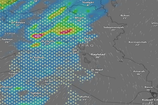
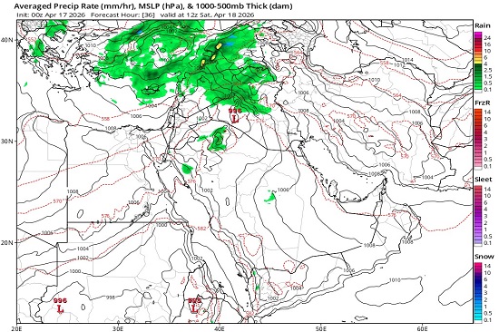
The Upper Euphrates Center for Sustainable Development Research at University of Anbar– Climatology Department – ??declared an update to the weather forecast based on satellite imagery. Dr. Ahmed Jassam Mukhlif, Head of Satellite Meteorology at the Center, stated that the European ECMWF model indicates a deep spring low-pressure system dominating Iraq, accompanied by severe disturbances and strong thunderstorms in the west, peaking on Saturday. Its effects will extend towards the north and center with varying intensities of rain. Gradual stabilization will begin on Sunday, with temperatures gradually rising, especially in the south, towards the end of the period, as follows:
The weather updates, according to numerical models, indicate:
Friday: The system will begin in the evening with scattered thunderstorms and showers of varying intensity.
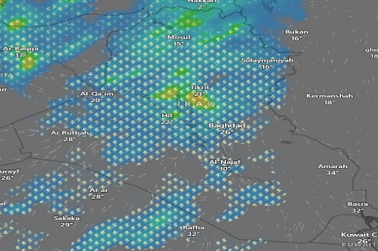
Saturday (peak of the weather system): The country will experience strong to severe thunderstorms and heavy rain. Hail is expected, particularly in southern Mosul, northern Anbar, and Tikrit, and may occur in large quantities and sizes. Surface winds may reach speeds of over 65 km/h, with the possibility of local dust storms in desert areas and a risk of flash floods in those regions.
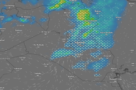
Sunday: The weather disturbance will continue but its intensity will gradually decrease. The storm will be concentrated in Dohuk, Erbil, Sulaymaniyah, and Diyala, while the chance of thunderstorms will remain in other areas, though less intensely. The impact will diminish across the western part of Iraq.
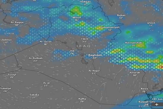
Monday: Thunderstorms and rain will be concentrated in the northern and northeastern parts of the country, as well as the far south and eastern regions.
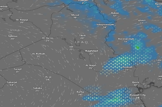
Tuesday: Light rain will be limited to the mountainous areas in the north and the southeastern parts of the country.
Wednesday: The low-pressure system will dissipate from the country.
Thermal Forecast:
Northern Region
Saturday: Low temperatures (15–20°C).
Sunday: 13–16°C, relatively cool.
Monday: Moderate temperatures (17–20°C).
Tuesday: 14–19°C, noticeably cold in the mountains.
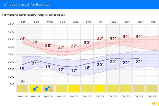
Central Region:
Saturday: Moderate temperatures (26°C in Baghdad, 30°C in Najaf).
Sunday: 20–22°C.
Monday: 23°C.
Tuesday: 22–26°C.
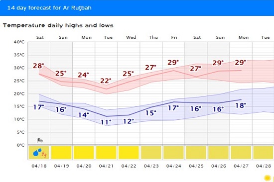
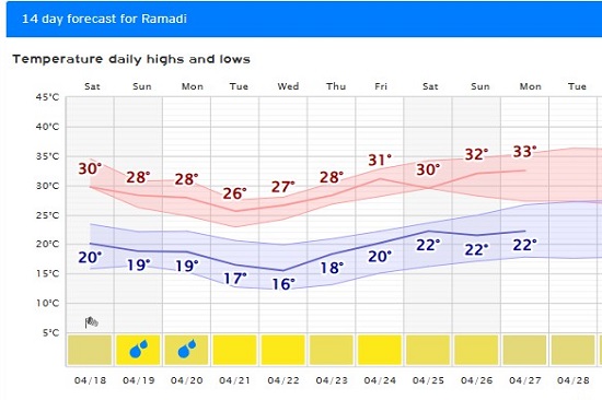
Western Region:
Saturday: 20–28°C, varying between mild and warm.
Sunday: 17–22°C.
Monday: Stable temperatures (22–26°C).
Tuesday: 22–26°C.
Southern Region:
Saturday: High temperatures (32–34°C). Sunday: Temperature 24–25°C.
Monday: Temperature 29°C.
Tuesday: Temperature 30°C, sunny and stable weather.
Allah knows best. May Allah grant success and guidance.
It is worth noting that the Upper Euphrates Center for Sustainable Development Research at University of Anbar continues to issue updates on meteorological observations and flash flood records, in addition to expected flood maps, as part of its program to monitor climate change and build robust databases to support researchers, specialists, and graduate students. This aligns with Anbar University's strategic plan to enhance its role in serving the community and achieving the Sustainable Development Goals and Vision 2030.
Recommendations
Recommendations for this weather situation: Due to the intensity of the spring low-pressure system and its severe effects, especially in the west and north, the most important recommendations are:
- Public Safety:
- Avoid being in open areas during thunderstorms due to the risk of lightning.
- Exercise caution when using highways due to the possibility of sudden dust storms or flash floods in low-lying areas.
- Daily Activities:
- Postpone outdoor activities and trips during the peak of the weather event on Saturday.
- Continuously monitor weather updates to avoid unexpected weather surprises.
- Agriculture and Irrigation:
- Take advantage of rainfall in the northern and western regions, while being aware of the potential for heavy precipitation that could lead to water accumulation or flash floods.
- Protect sensitive crops from hail and lightning strikes.
- Utilities and Services:
- Ensure that exposed signs and equipment are secured to prevent them from being blown away by strong winds.
- Be prepared for potential power outages in some areas due to lightning or wind.
#Upper_Euphrates_Center_for_Sustainable_Development_Research