| News Details |
Weather forecast for the next few days
2025-06-29
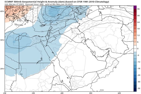
The Meteorological Department of the Upper Euphrates Center for Sustainable Development Research at the University of Anbar announced the weather forecasts for the next few days through satellite monitoring. Assis. Prof. Dr. Ahmed Jassem Mukhalaf, a climate expert and satellite meteorologist, reported a relative decrease in temperatures that alleviates the heat in Iraq due to the rare descent of a cold trough at the 500 millibar level.
Temperatures:
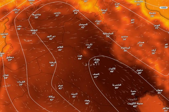
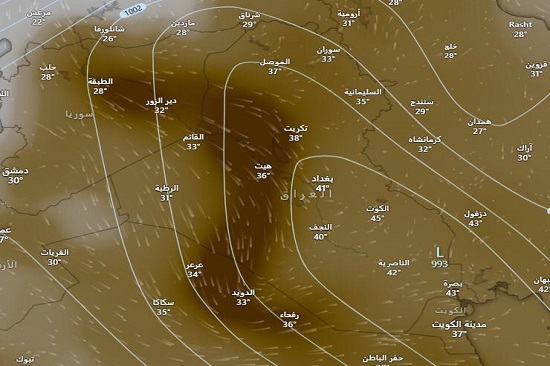
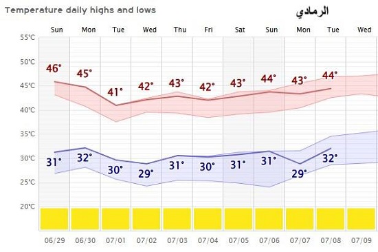
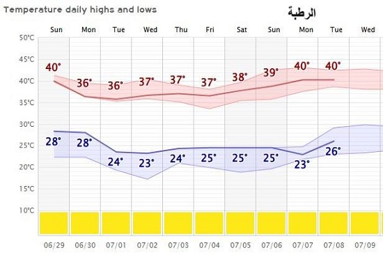
With the beginning of the seventh month, a sudden drop in temperatures is expected in Iraq due to the extension of a rare upper cold trough that is affecting northern Egypt, the Levant, northern Saudi Arabia, and Turkey, and will impact the western and northern parts of Iraq, potentially causing rainfall, especially in Turkey. In Iraq, the effect will only be on temperature moderation, with temperatures expected to drop below 40 degrees Celsius in the northern and western regions of Iraq, while the capital, Baghdad, is expected to record a temperature of 41°C. The southern region may be affected by this drop on 2/7/2025, with temperatures in Basra reaching 45°C after previously recording 50°C.
This comes after a surge of hot air to Western Europe (Spain, Portugal, France, and Italy), where recorded temperatures reach nearly 40 degrees Celsius in high humidity conditions.
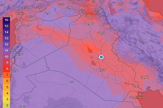
Ultraviolet (UV) rays:
In general, its levels are high on Saturday, June 28, 2025, reaching their highest point in the western part of Iraq, with an index value of (11), as well as in the mountainous areas in the north of the country. The lowest levels are in the eastern parts of the country, with the central and southern regions reaching an index value of (8). It is also unhealthy (it is advised to avoid exposure to its rays during peak hours (12-2 PM) unless necessary, and to wear light clothing that covers the body and is of light colors).
The winds conditions:
In terms of direction, it will be from the west to the northwest, having an active and temperate effect on the atmosphere, especially in the northern and western regions of the country. As for speed, there may be a convergence between two different pressure systems with high pressure differences, as follows:
The western region:
Moderate speed, with the highest speed over the 14 days (40 to 45 km/h on July 7-9, 2025).
Northern region:
Its highest speed in Erbil on Sunday and Monday, 30/6/2025, is expected to reach (44 to 55 km/h), while in Sulaymaniyah from Saturday to Monday, 28-30/6/2025, it will range from 48 to 50 km/h. The rest of the days will have moderate speed.
Central region:
Moderate speed, except on Monday, 30/6/2025, and 7/7/2025, when it is expected to reach 48 km/h.
Southern region:
Moderate speed, except for Tuesday and Wednesday, July 1-2, 2025, when it is expected to reach 52 to 54 km/h.
Dust condition:
It is expected that the dust condition will become active starting from the evening of Saturday, June 28, 2025, and it will have a limited impact due to the active winds, as its source will be from the Badia Desert of Sham, with the following areas affected:
Saturday evening:
Mosul, Tikrit, and northern Anbar.
Sunday: Its impact will only recede in the evening in Mosul.
Monday: Its impact will increase on Monday evening, covering Mosul, Tikrit, Anbar, Najaf, Karbala, and reaching Samawah.
Tuesday: Its impact will be limited to Mosul, northern Anbar, Samawah, Nasiriyah, and Al-Suwayrah.
Wednesday: Its focus will be on Mosul and northern Anbar.
As for the rainy conditions, there is no hail or rain as rumored in the media. Please be accurate in disseminating such misleading information, and it is advisable to obtain information from specialized sources.
#Upper_Euphrates_Center_for_Sustainable_Development_Research